

The Google Maps service is receiving its biggest update in the last ten years. The company is launching a new driving experience called “Immersive Navigation,” which opens a new era with a fresh look and useful changes.
New Three-Dimensional Design
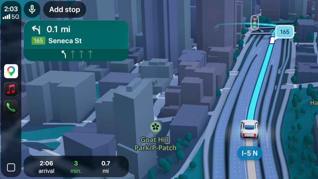
The new design immediately grabs attention, as users get a 3D map that uses information from Street View to create a much more realistic image of the surroundings. This includes buildings, overpasses, and even landscaping.
This not only looks much better than previous maps but also promises to help drivers navigate unfamiliar places better.
The new display also highlights important elements such as traffic lanes, pedestrian crossings, traffic lights, and stop signs.
Useful New Features
While the new design looks great, Google didn’t just apply a new coat of paint. On the contrary, they are also launching a series of new features.
This includes more natural voice guidance, as well as “smart zoom and transparent buildings.” The latter allows users to see through buildings and preview the upcoming route, including complex turns and lane changes.

Improved Explanation of Alternative Routes
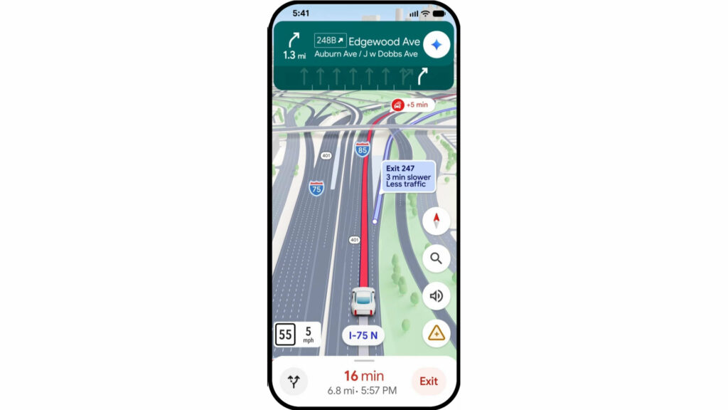
Another update better explains alternative routes. Maps receive about five million traffic updates per second, which means constantly searching for the best path for you.
The latest version of Maps will show you alternative routes and their trade-offs. For example, imagine you’re driving on a highway and there’s an accident ahead. While you’re stuck in traffic, Google will notify you about the accident and show an alternative route at the nearest exit.
Maps could explain that this route has less traffic but will add three minutes to your trip. This allows drivers to choose whether they want to reach their destination faster or avoid congestion and stress.
Additionally, drivers can prepare for future trips using the preview feature, which shows how you will get to your destination. Furthermore, users can view Street View images and get parking spot recommendations.
Immersive Navigation begins rolling out today in the United States and will gradually expand to Android and iOS devices, as well as cars with Android Auto, Google built-in, and Apple CarPlay.
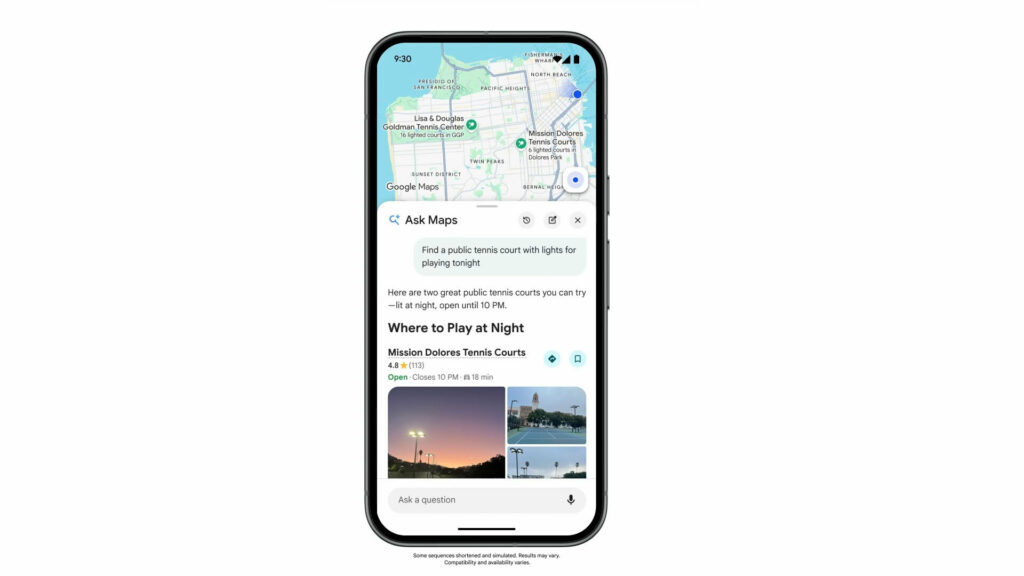
Ask Maps – Your AI Assistant
Another major update is the introduction of Ask Maps, powered by Gemini AI. As the name implies, users will be able to ask questions and receive complex answers regarding destinations, places to visit, and dining spots.
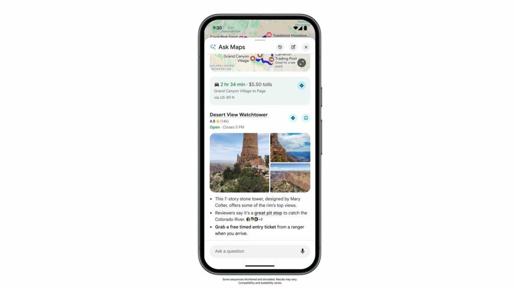
This is useful, but the technology can be used for planning multi-day vacations. For example, suppose you’re embarking on a three-day trip to visit the Grand Canyon, Horseshoe Bend, and Coral Dunes.
Ask Maps can recommend the perfect route, as well as stops along the way. It will also provide photos and information about the route, such as tolls. During yesterday’s preview, Maps even offered “insider tips,” such as avoiding certain parking lots that are usually full.
To help compile these suggestions, Maps analyzes information from the Internet, as well as its database of over 300 million places. The technology also considers feedback from over 500 million users.
Ask Maps even knows a bit about you from previous Google Maps searches and saved places. This helps personalize recommendations based on things you already like or are interested in.
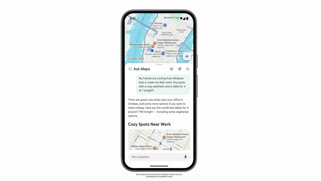
For example, you could say something like: “My friends are coming from Midtown East to meet me after work. Are there any cozy places with a table for 4 today at 7:00 PM?” Since Maps already knows which restaurants you like, they will suggest options that appeal to you. You can even book a table through the app and share the details with friends.
Essentially, Maps is becoming smarter, more conversational, and can help you choose destinations. The possibilities are practically endless.
Ask Maps is rolling out now in the United States and India on Android and iOS devices, while desktop functionality will appear soon.
These updates demonstrate a clear trend of transforming Google Maps from a simple navigator into a comprehensive digital travel and planning assistant. The integration of artificial intelligence not only simplifies finding a route but also attempts to anticipate user needs, offering personalized solutions. Such changes could significantly impact how people interact with the city and plan their free time, making the process more intuitive and less stressful. The success of these innovations will largely depend on data quality and the system’s ability to understand context in different regions of the world.